Fiché:Europe, 1714.png
Tay di sa apèrsou : 800 × 546 piksèl. Ròt rézolisyon : 320 × 219 piksèl | 640 × 437 piksèl | 1 024 × 699 piksèl | 1 280 × 874 piksèl | 1 590 × 1 086 piksèl.
Fiché d’orijin (1 590 × 1 086 piksèl, tay di fiché : 986 kio, tip MIME : image/png)

|
Cette image (de type map of europe) devrait être recréée dans un format vectoriel, en tant que fichier SVG. Cela offrirait plusieurs avantages : voir Commons:Media for cleanup pour plus d'informations. Si une version SVG de cette image est déjà disponible, merci de bien vouloir l'envoyer. Après cela, remplacez ce modèle par {{vector version available|nouveau nom d'image.svg}}.
|
_en.png)
.png)
.jpg)
Dèskripsyon
| Dèskripsyon |
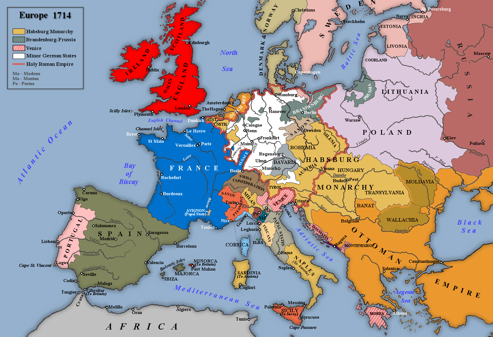
English: Map of Europe in 1714 |
| Dat | |
| Sours | Travay pésonnèl |
| Zotò | Rebel Redcoat |
Kondisyon di litilizasyon
| Moi, propriétaire des droits d’auteur sur cette œuvre, la place dans le domaine public. Ceci s'applique dans le monde entier. Dans certains pays, ceci peut ne pas être possible ; dans ce cas : J’accorde à toute personne le droit d’utiliser cette œuvre dans n’importe quel but, sans aucune condition, sauf celles requises par la loi. |
Listorik di fiché
Kliké asou roun dat ké lèr pou wè fiché-a tèl ki li té yé pannan sa tan-an.
| Dat ké lèr | Vignèt | Dimansyon | Itilizatò | Koumantèr | |
|---|---|---|---|---|---|
| atchwèl | 2 mè 2014 à 14:42 | | 1 590 × 1 086 (986 kio) | Spiridon Ion Cepleanu | According with H.E.Stier (dir.) Grosser Atlas zur Weltgeschichte, Westermann 1984, p.119, ISBN 3141009198, & all sources, the Danubian principalities were not turkish provinces but christian states (ruled by Greek hospodars), vassal of the Ottoman sult... |
| 7 janvyé 2014 à 16:21 |  | 1 590 × 1 086 (1,07 Mio) | Rebel Redcoat~commonswiki | Some minor improvements/accuracy | |
| 17 janvyé 2013 à 08:59 |  | 1 590 × 1 086 (1,06 Mio) | Rebel Redcoat~commonswiki | Added St. Petersburg | |
| 26 mè 2012 à 12:00 |  | 1 590 × 1 086 (1,06 Mio) | Rebel Redcoat~commonswiki | Correction: Sicily | |
| 6 mè 2012 à 15:48 |  | 1 590 × 1 086 (1,06 Mio) | Rebel Redcoat~commonswiki | Better quality | |
| 17 jen 2010 à 20:30 |  | 1 594 × 1 090 (222 kio) | Rebel Redcoat~commonswiki | {{Information |Description={{en|1=Map of Europe in 1714}} |Source={{own}} |Author=Rebel Redcoat |Date=18 June 2010 |Permission= |other_versions= }} Category:Maps |
Litilizasyon di fiché
Paj ki ka swiv ka itilizé sa fiché :
Lizaj global di fiché
Ròt wiki-ya ki ka swiv ka itilizé sa zimaj :
- Litilizasyon asou ar.wikipedia.org
- Litilizasyon asou bg.wikipedia.org
- Litilizasyon asou ca.wikipedia.org
- Litilizasyon asou en.wikipedia.org
- Litilizasyon asou fa.wikipedia.org
- Litilizasyon asou fr.wikipedia.org
- Litilizasyon asou id.wikipedia.org
- Litilizasyon asou ja.wikipedia.org
- Litilizasyon asou mk.wikipedia.org
- Litilizasyon asou nl.wikipedia.org
- Litilizasyon asou nn.wikipedia.org
- Litilizasyon asou ru.wikipedia.org
- Litilizasyon asou sh.wikipedia.org
- Litilizasyon asou tr.wikipedia.org
- Litilizasyon asou uk.wikipedia.org
- Litilizasyon asou www.wikidata.org