Fiché:USA Territorial Growth small.gif
Pa di pli rot rézolisyon disponnib.
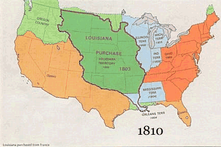
USA_Territorial_Growth_small.gif (431 × 287 piksèl, tay di fiché : 456 kio, tip MIME : image/gif, en boucle, 10 trames, 30 s)

|
Ce fichier a été remplacé par File:USA territorial growth.gif. Il est recommandé d’utiliser l’autre fichier. La suppression des fichiers remplacés requiert un accord.
|

|
Dèskripsyon
| Dèskripsyon |
English: US territorial growth 1810–1920, based on the PD USGS maps in Category:Territorial growth maps of the United States.
See key below for explanation of colors.  |
||||||
| Sours |
|
||||||
| Zotò |
|
||||||
| Autres versions |
|
Kondisyon di litilizasyon
Cette image est placée dans le domaine public parce qu'elle contient des éléments issus de l'United States Geological Survey, une agence du Département de l'Intérieur des États-Unis. Pour plus d'information, consultez la politique officielle de copyright de l'USGS (en anglais)
|
Listorik di fiché
Kliké asou roun dat ké lèr pou wè fiché-a tèl ki li té yé pannan sa tan-an.
| Dat ké lèr | Vignèt | Dimansyon | Itilizatò | Koumantèr | |
|---|---|---|---|---|---|
| atchwèl | 30 mè 2006 à 07:50 | | 431 × 287 (456 kio) | Roke~commonswiki | US territorial growth, based on the PD USGS maps in Category:USA Territorial Growth Maps Category: USA Territorial Growth Maps {{PD-USGov-USGS}} |
Litilizasyon di fiché
Paj ki ka swiv ka itilizé sa fiché :
Lizaj global di fiché
Ròt wiki-ya ki ka swiv ka itilizé sa zimaj :
- Litilizasyon asou ar.wikipedia.org
- Litilizasyon asou be-tarask.wikipedia.org
- Litilizasyon asou be.wikipedia.org
- Litilizasyon asou ca.wikipedia.org
- Litilizasyon asou ckb.wikipedia.org
- Litilizasyon asou da.wikipedia.org
- Litilizasyon asou fr.wikipedia.org
- Litilizasyon asou fy.wikipedia.org
- Litilizasyon asou hr.wikipedia.org
- Litilizasyon asou id.wikipedia.org
- Litilizasyon asou it.wikipedia.org
- Litilizasyon asou jv.wikipedia.org
- Litilizasyon asou kk.wikipedia.org
- Litilizasyon asou ro.wikipedia.org
- Litilizasyon asou sh.wikipedia.org
- Litilizasyon asou sl.wikipedia.org
- Litilizasyon asou sr.wikipedia.org
- Litilizasyon asou tr.wikipedia.org
- Litilizasyon asou uk.wikipedia.org